
Quakesmart:CA
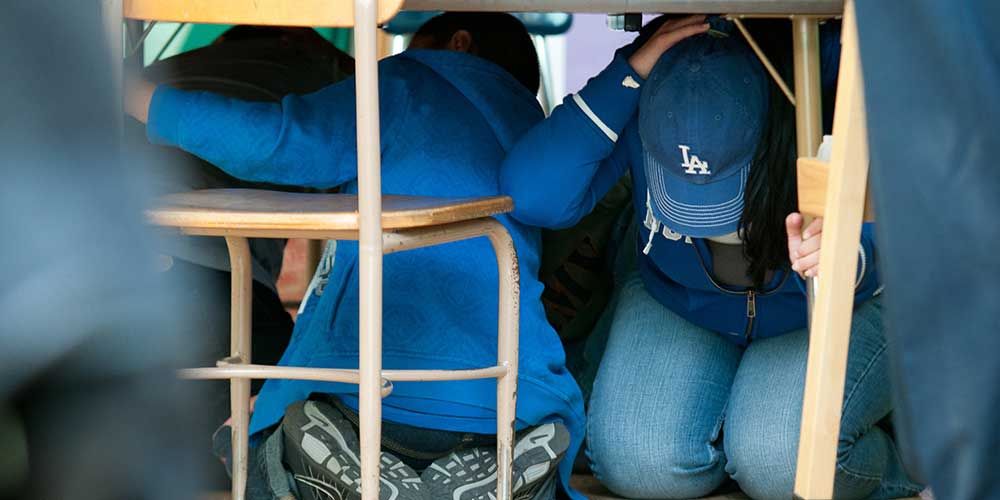
Earthquakes happen without warning. You need to know what to do when the next one strikes. The minute the ground starts to shake, you should:
Drop
Drop to the ground
Cover
Cover your head and the back of your neck
Take Cover
Take cover beneath a sturdy piece of furniture like a desk
Hold On
Hold on to that piece of furniture until the shaking stops
Practice makes perfect; practice makes permanent. Make sure to practice DROP, COVER, and HOLD ON once a month with your family and classmates or colleagues.
NOTE: If you or someone you know has a disability that may prevent them from getting under a desk or table, share this important PDF document that explains what to do if you are managing a disability. Developed by the Earthquake Country Alliance, the information it provides is priceless.
It isn’t a matter of “IF”, but “WHEN.”
The United States Geological Survey (USGS) estimates that Southern California has a 99.7% chance of experiencing a large, destructive earthquake in the next 30 years. 99.7%. The odds for central and northern California may be slightly less, but still hover around 97%. It’s difficult to get more likely than that.
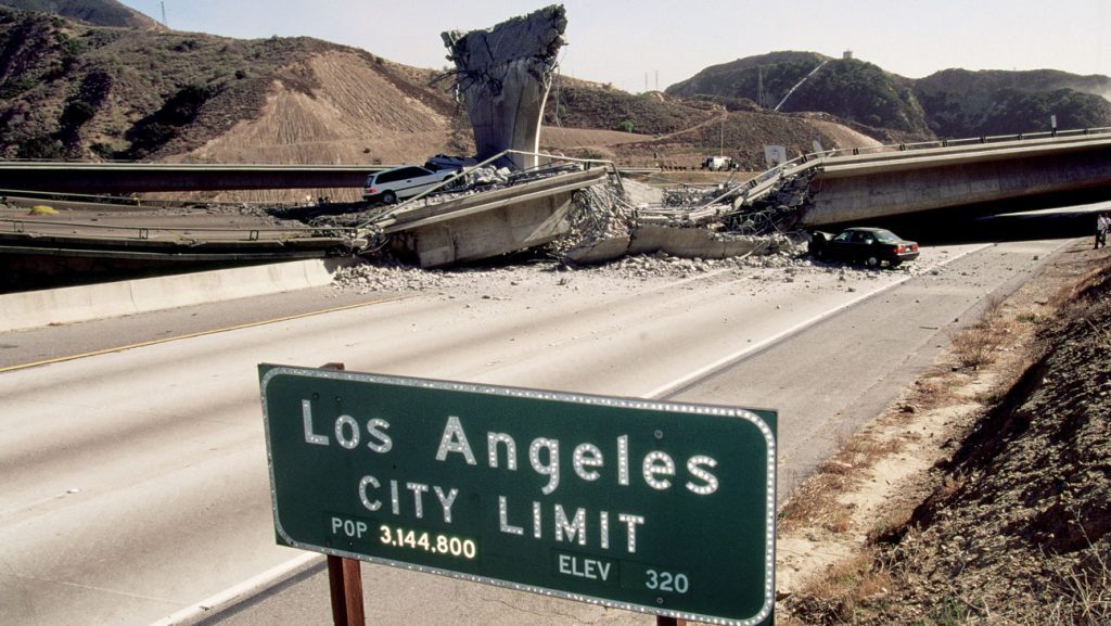
Geologists have identified many dozens of dangerous fault lines that are either new, or haven’t been active for many years. Many of these faults are capable of producing widespread damage if they rupture. And these are only the faults we know about. As an example, in 1994 when the Northridge Earthquake struck Los Angeles, killing at 57 people, and injuring another 8,700, it occurred on a fault scientists didn’t even know existed.
When the southern end of the region’s largest fault, the San Andreas, ruptures (and it is more than 160 years overdue for just such an “adjustment”) experts predict there will be over 1,700 fires in Southern California within minutes. If a 6.6 magnitude earthquake were to strike in a large city, there is concern the entire area would be destroyed by fire. When this happens, the fire department and other life saving agencies will be overwhelmed. They’ll have no choice but to respond to the largest, most crucial emergency calls, which means the vast majority of us will only have ourselves and each other to rely upon.
Tsunami Threats are Larger than Previously Thought
Californians don’t typically think too much about Tsunamis following a significant earthquake. Tsunamis are huge ocean waves that can reach more than 100 feet in height. They are typically caused by earthquakes; the 2004 Banda Aceh earthquake and tsunami killed about 250,000 people, while the 2011 Tohoku earthquake and tsunami that struck offshore of Japan killed about 18,500 people and triggered a nuclear disaster. More recently, Anak Krakatau erupted and damaged local seismographic equipment. It took several days to determine that in fact a significant tsunami had occurred, although the loss of life was lower than that of Tohoku – 426 dead and 7,202 injured.
Tsunamis increase in size as the depth of water in which they occur decreases. As water depth decreases along the California coastline, a tsunami could increase in size substantially as it approached land, becoming particularly dangerous along heavily populated coastlines, such as those in Southern California.
Recently, scientists did a tsunami study that focused on the Ventura Basin in Southern California, which has offshore faults that may generate earthquakes of magnitude 7. The researchers developed 3D models of fault ruptures on the 31-mile-long (45 kilometers) Pitas Point and 22-mile-long (35 km) Lower Red Mountain undersea faults.
Although homes and buildings on the coastlines directly opposite these faults would naturally be vulnerable to any tsunamis, until now, additional low-lying areas farther to the east were not necessarily expected to be in harm’s way. The new study suggests the cities of Ventura and Oxnard might be under greater threat of tsunami flooding than was previously considered.
Scientists and emergency responders coordinate their efforts to help residents understand the threat of a tsunami. The create maps, called inundation maps to help people know where the treat of a tsunami is greatest. You may search for a map in your area via this link.
Overall, the chances of an earthquake like the one the researchers simulated striking Southern California are low. “The earthquake scenario considered in the recent study was huge,” said CalFire Prevention Director Cameron Barrett. “Such a quake would be in the top three the state has recorded in hundreds of years. That’s a good reason to consider the possibilities, as we are often dismissive of the power mother nature can render.”
The Time To Prepare is Now!
- Impact as many as 10 million people
- Injure of kill as many as 11,000 people
- Cause $20 billion in damages
- Effect major infrastructures for months, including water, power, Internet, and telephone
As Dr. Jones says, “everyone needs to store more water, and they need to learn how to use a fire extinguisher.”
The California Fire Prevention Organization provides education and awareness materials for communities throughout the State of California.